|
I want to explain how this all
came about as the background may lend confidence to your decision
to use the information or not. October 2018 I was sailing south
through the Sandy Strait and exited the bar on a fairly quiet
(10 to 15 kts) morning. The tide was LOW SLACK! I firgured I
would have a look and see.
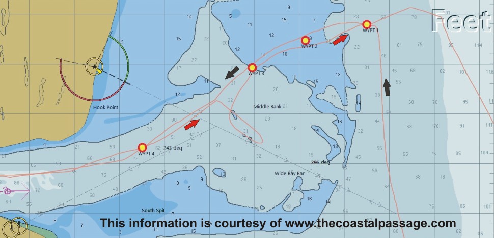
I noticed that the leads on Inskip
Point (lower left in image) were not useful. There was breaking
water on the suggested course. The red arrow indicates my course.
I had heard that the point to turn SE was about 200 meters further
than indicated on charts like my CM93 charts above. I changed
course as soon as I found a gap in the breakers and carried it
until it became obvious I wasn't going to make it. That is why
the loop in my course. I saw a fishing boat had come in and from
a more northerly entrance so I just carried on until i found
a path through and it worked well. It was tense as it was new
ground but we were never in danger on that track.
Then... making north a few weeks ago
we were anchored at Double Island Point where wind was being
recorded at 30 kts. To work the tide up the strait I needed to
clear the bar early, about a quarter of a making tide. Conditions
were very rough. Another cat went ahead of me which surprised
me. I followed their course via AIS to see if they knew something
I didn't! They attempted to make the usual path but were beat
back. My recent track is marked with black arrows in the image
above. See additional text following the image below. |