|
Love the Louisiades!
2009
Guy Chester, EcoSustainAbility, Rally Organiser
Trying Navigation
In 1991 I sailed in (and won!) the Coral Sea Classic from Cairns
to Port Moresby. It had been a fast but wet passage, it was completely
overcast for the whole trip and our Transit Satnav (before GPS)
had last received a position two days ago as we passed the Norman
Reef tourist pontoon in Trinity Opening, just outside of Cairns.
The now ageing transit Satnav in the best of times got a fix
each two to six hours, depending on the passage of satellites,
a fix was an agonising forty or so minutes during which one needed
to input precise course and speed data for the fix to have any
accuracy. Even then it told where you had been forty minutes
ago! GPS had recently been launched and the decline in transit
satellites meant less reliable and less frequent fixes.
Whilst in those days I was adept at sun
sights, even doing dawn and dusk star fixes, one's sextant just
could not see through cloud. We knew we had sailed the 420 miles
by the log, we thought we had held pretty much to course (but
shy reaching in 25 knots with a spinnaker does leave some room
for doubt as to both potential leeway and weather helm during
all too frequent round ups and broaches!). The light to the reef
passage only had a range of twenty miles... whether our cross
track error was even within the range of the light was the question.
We also knew we were ahead of larger boats
and very well placed on handicap.. in the running for the $10,000
cash prize...the incentive to keep racing was strong. As rain
squalls reduced visibility to metres and the on the chart the
unbroken barrier reef in front of Port Moresby looked just a
tad treacherous, I called to the crew to drop the kite and that
we would have to heave to and wait better visibility or dawn.
Prudent seamanship ruled over reckless racing. Just then through
the gloom a ship was seen just off the starboard bow, we crossed
its bow and took a compass bearing down the two white steaming
lights (bow and stern). We assumed it must have come through
the Basilisk Passage, and we headed along its reciprocal course..
twenty minutes later we saw the light, entered the reef passage
and won the race!
Needless to say the $10,000 prize was promptly
spent, $5,000 on a GPS.. (remember one can nowadways buy one
from Kmart for $200!). The relaxed passage across a windy and
overcast Coral Sea and entry into Palm Passage on our way back
to Townsville with the new GPS has been at the forefront of my
mind whenever we sail near coral or its an overcast on passage.
I am embarrassed to say I no longer carry a sextant.
The bar room discussion in Port Moresby
was of course our great sailing, and of course our skilled navigation
in the trying conditions. We may have neglected to own up to
the fortuitous ship and its passive navigational "advice",
but I cannot recall, $10,000 goes a long way when you shout the
bar! However, I do recall the awe we all had for the early navigators,
those without satnav or the new fangled GPS, those without even
charts.. who bravely sailed along treacherous reefs charting
them.
The conclusion of the Coral Sea Classic
was a two week cruise along the southern Papuan coast and the
islands of Milne Bay (just to the west of the Louisiades proper).
The Earliest Navigator
With a name sounding quite French and an interest in the Louisiades
I started to investigate the history of the area. Of course the
local folk have lived there for many many years.. but how did
the Jomard Passage, Duchateau islands, Rossell and the Louisiades
get their names? Well it turns out there was a French navigator
named, well you guess it Louis! Louis-Antoine de Bouganville
was a French Navy navigator who sailed through the Louisiades
in 1768, yes that's two years before Captain Cook "discovered"
the east coast of Australia. Bouganville had been instrumental
in fighting off the British in whats now the french speaking
part of Canada and after being involved in settling the Falkland
Islands (subsequently given to the Spanish by the French, much
to Bouganville's disgust), Bouganville set off on Pacific voyages
of discovery.
Bouganville gave his name to the tropical
flower and his son, forty years later, followed his father as
a navigator and named Bouganville Island in northern PNG. However
it is thought that in 1768 the name Louisiades is in honour of
France's head of state, Louis. In 1768 Bouganville sailed along
the southern reefs of the Calvodos Chain of the Louisiades. The
chain of barrier reefs are ten to twenty miles south of the islands.
It would have been a treacherous voyage, headwinds and cloudy
skies making depicting reefs ahead difficult as he worked east
to what's now Rossell. He then headed off to the north west to
the Philipines and the Far East via the South China Sea. In those
days, when not "discovering" the navigators could only
go where there were known charts and places (New Guinea, Torres
Strait and Australia were only dimly known of from earlier Dutch
navigators).
Bouganville missed out on discovering Australia,
but did find this jewel of a chain of islands, the Louisiades.
With Bouganville coming so close to Australia I am left wondering
how "G'day Mate" would sound in French!
Interestingly it was an English navigator
Owen Stanley who spent the time charting the Louisiades with
two vessels in the early 1800's. He went ashore rarely as he
found the locals a tad aggressive, although less so in the Louisiades
Islands than the Papuan coast to the west. Owen had a seizure
or stroke during this voyage, his surgeon thought this from the
worisomeness of such perilous navigation around coral reefs.
He died aboard his ship anchored in Sydney Harbour shortly after
his charting of the Louisiades. Owen gives his name to the Owen
Stanley Range along Papua New Guinea (the "hills" the
Kokoda track climbs over).
Re-Discovering the Louisiades
My brief sojourn to the PNG islands in 1991 left a lust for more,
and after fifteen years of Queensland coastal sailing and a two
year Pacific cruise it was time to head back to the Louisiades
for a better look. So in 2007 we headed up to the islands for
a five week planning trip to determine the feasibility for a
rally. We found the locals support for a Rally was overwhelming
and we felt an obligation to bring the event to fruition.
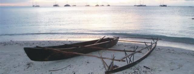
The Islands and People
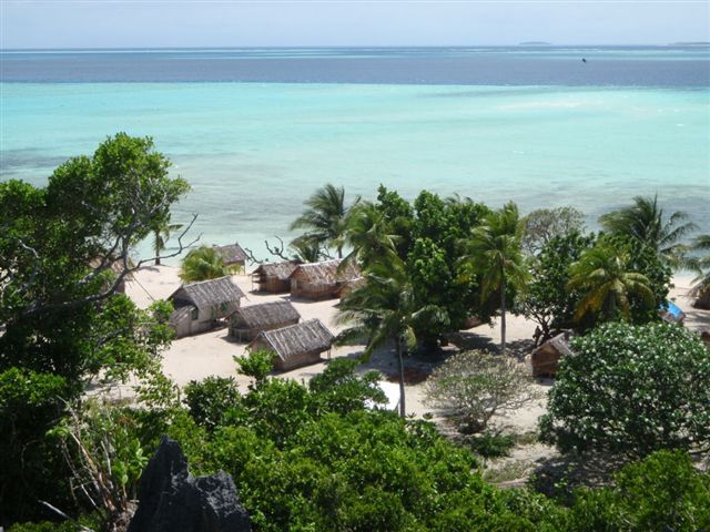
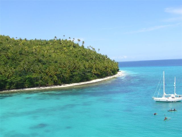
The Louisiades are a chain of tropical reefs and islands to the
east of mainland Papua New Guinea and are just 520 nautical
miles across the Coral Sea north-east of Cairns. The islands
are spectacular and provide many safe anchorages. With abundant
coral reefs there is snorkelling, diving and fishing galore.
There are skull caves and hills to climb, coral reefs to snorkel,
cays visit, mangrove lined creeks, coconut shaded beaches, lagoons,
creeks, waterfalls and shady forests to explore.
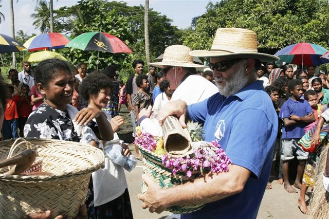
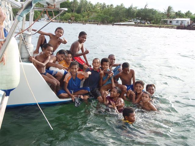
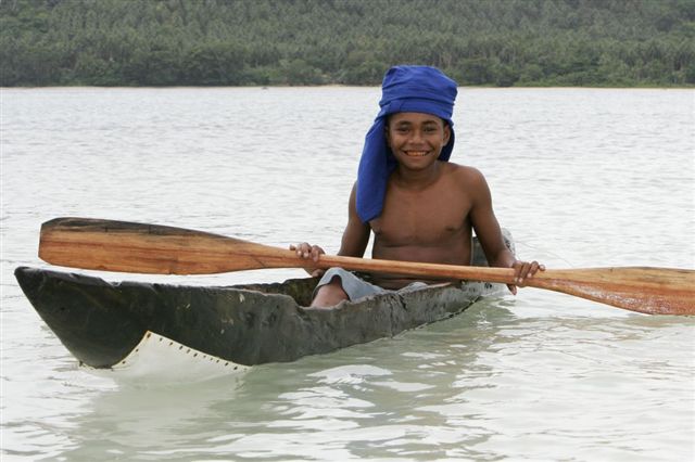
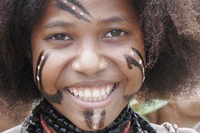
They are inhabited by very welcoming Melanesian
people who have little cash economy and look forward to festivities
and trading with the yachts. The islands and people are fantastic,
so welcoming its often embarrassing. Most folk live in villages
with from one family to hundreds. There is no formal traditional
chiefly system but it seems every island has a councillor who
sits on the local government. Councillors are elected so they
do change each five years or so.
The Rally
After our planning trip in 2007, we ran the first Louisiades
Rally last year. The Rally is a great experience for us, the
yachties. Those with no previous offshore cruising experience
to those with tens of thousands of miles of bluewater experience
enjoyed the Rally last year. The locals also enjoy the Rally
and the islands we visit are already planning their welcome for
yachts this year!
Based on other cruisers experiences and
local knowledge from the Louisiades, June-August can be pretty
windy and wet, the south easterlies tend to be a bit fiercer
at this time. Returning to Queensland by mid November gets folk
off the Coral Sea for the cyclone season (although they can occur
earlier!) and allows an easier return down the Queensland coast
with the November/December light northerlies.
Why Join a Rally?
We planned the Rally as a cruise in company across the Coral
Sea to the spectacular Louisiades, with a mix of events (ranging
from sailing canoe racing, feasts, sing sings, skull cave visit,
traditional dancing, a remote river trip, school and hospital
visits etc.) and time for independent exploration of the islands
and their friendly communities.
The support we provide for the Rally yachts
includes safety and navigation briefings, Cairns marina berth
(Yorkeys Knob Boating Club), weather, radio skeds, Australian/PNG
customs arrangements and many events in the Louisiades. Additional
support includes attractive Bluewater extension insurance arrangements
with Club Marine, arranging radio checks and rig checks and equipment
suggestions.
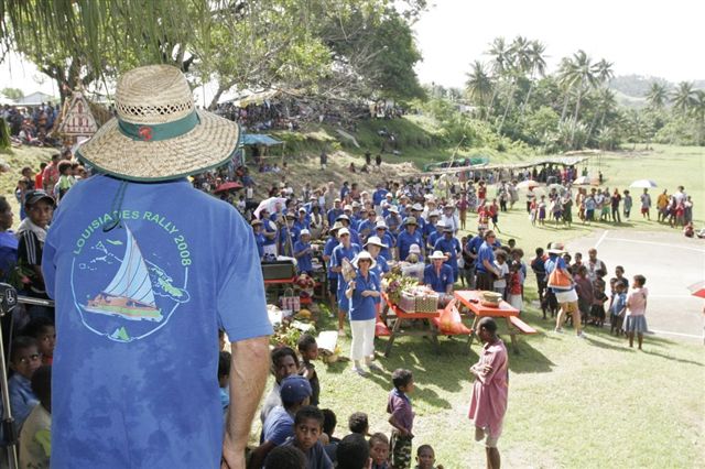
2008 participants said the major benefits
of the Rally were the safety briefings and cruise in company
aspects, and the community events which would otherwise not be
experienced by independent cruisers.
What's Planned for 2009
Events include farewell drinks at Yorkeys Knob, arrival BBQ,
skull cave visit, traditional dancing, village visits, cultural
festival, traditional sailing canoe regatta, beach BBQ, "Showcase
Misima" festival, remote river and waterfall trip, school
visit, clinic visit, sports day, traditional canoe making, traditional
carving and the rally end party.
The muster at Yorkeys Knob and the week
prior to departure is about final preparations, briefings and
getting to know the fellow yachties. We are also arranging radio
inspections and rig checks for yachts as required.
The departure date for the passage is of
course weather dependent, and each skipper makes their own decision
to leave! Once the 520 mile passage is completed yachts meet
up at the beautiful Duchateau Islands. The after a few days of
snorkelling, beach walks and beach sundowners, we all move on
the spectacular Panasia island.
After entering the narrow passage into
the lagoon, yachts have a BBQ with the local villagers and have
the "official' passage "presentation". A few days
to relax, or visit local islands such as Brooker before moving
on to the Deboyne group.
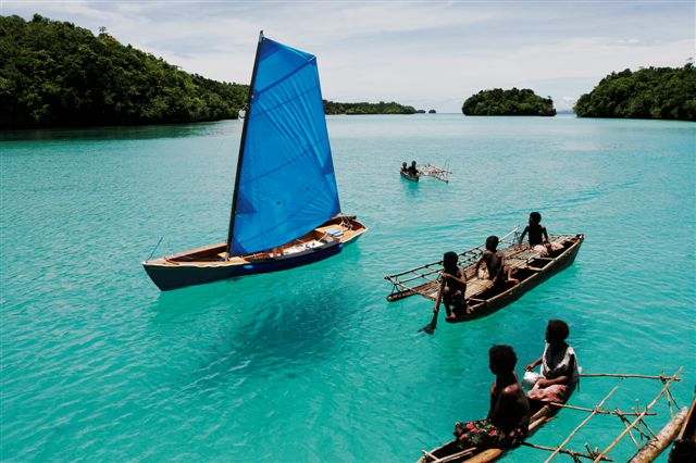
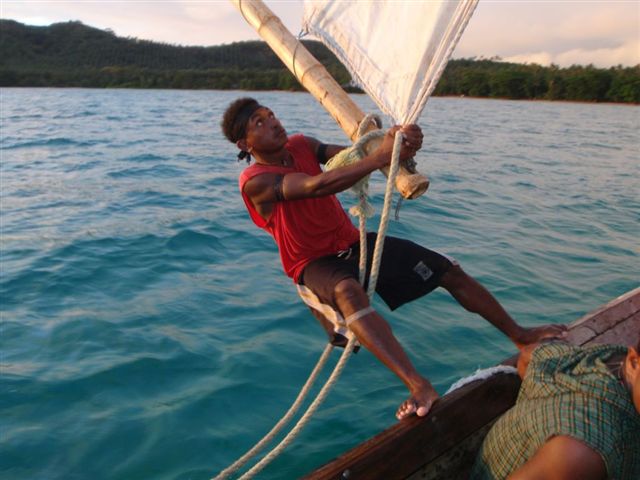
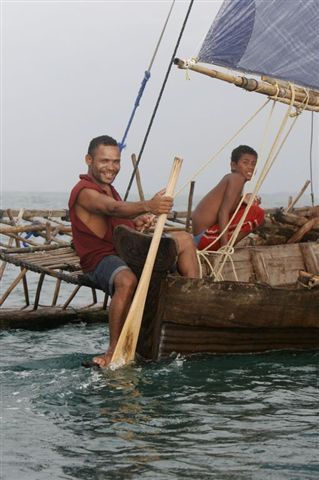
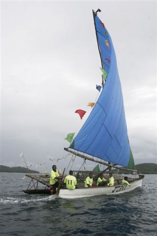
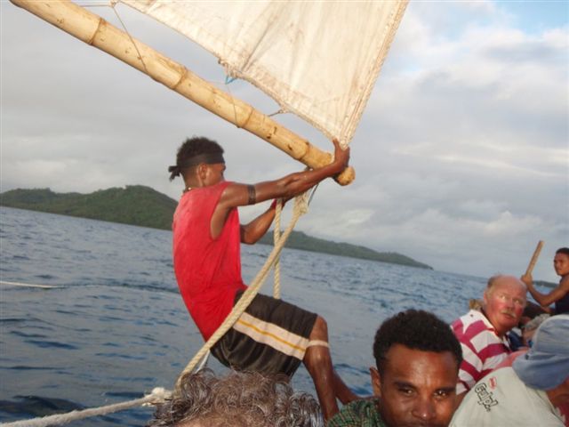
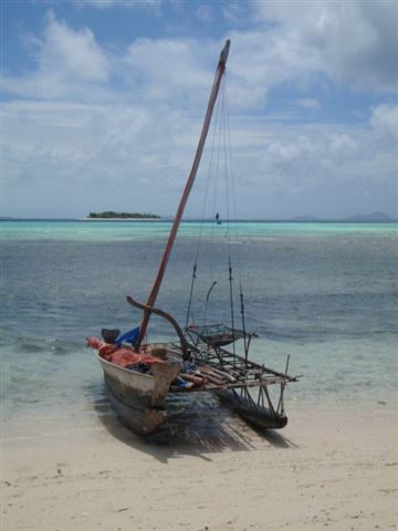
One of the highlights of the Rally is the
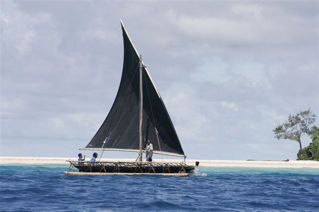
traditional sailing canoe (lakatoi) regatta, held at Panapompom
Island (one of the Deboyne Group), which after a hectic day last
year will be held over two days and see 30-50 of the traditional
sailing canoes racing. Lakatois are the local transport, they
are the truck, car and school bus for these island communities,
but they are no slouch, they will race past at 12-15 knots.
Again a few days before the next event
at Bagaman Island, where the locals arrange a cultural festival
for the day. Then the next day yachts go to the beautiful blue
Lagoon for a BBQ and day on the beach.
Misima is next, the small town of Bwagoia
and its tiny harbour venue. Yachts must raft up and this is where
the PNG customs formalities are completed. The locals put on
a major two day festival "Showcase Misima" in 2008
and they are planning a similar event for 2009!
With a week or so to cruise to any of the
many islands such as Jimmy's yacht club at Kamatal or the magical
lagoon at Sabar, yachts meet back up again at Wanim for a party
on the beach. Then on the next day a short sail to the Nimowa
mission for a one day river trip in long boats and then a day
visiting the mission school and clinic and a sports afternoon
where the yachties get to try their hand at soccer and netball.
Between the official events there is ample
time for individual cruising/exploring the many great anchorages
in amongst the protected waters of the Calvodos and Deboyne groups
which make up the Louisiades.
Competition
When two yachts sail on the same horizon they are of course racing…,
however the rally is not a race, nor do the organisers condone
any activity arranged outside the international rules for the
prevention of collisions at sea…(well OK, we do organise
the Canoe Regatta which appears to be "ruleless").
There are of course many competitions (biggest fish, biggest
sob story, worst dressed crew, worst breakage, best navigator
etc.) and some of these are fought over more seriously than the
Americas Cup. Well OK, not quite as seriously, the rally organisers
decision, whilst open to bribes (which go into the community
benefit kitty) is final, there is no recourse to the New York
Supreme Court to sort out serious sailing stuff here!.
Community Benefit
Whilst the Rally is organised for the yachties safety and enjoyment,
we also aim to support the local community and last year the
rally yachts took many items to donate to local schools and the
local clinic. Trading for items is also very popular and by rally's
end most yachts had exhausted their trading supplies (but had
their fill of fruits and lobster and returned with great carvings
and handicrafts).
Last year we took many goods to donate
(as well as trade goods), we spent over $15,000 on the events,
food, handicrafts and fuel etc., raised over $4,000 in donations
to clinics and the government spent over $15,000 on supporting
the Misima event. All support that would otherwise not reach
this remote and largely forgotten community.
Supporters
The Rally is supported by the Papua New Guinea Tourism Promotion
Authority and the Yorkeys Knob Boating Club. For 2009, Yachts
muster at Yorkeys by September 6 and depart 12 September, yachts
return to Australia mid October to mid November. Power and sail
boats are welcome!
2010 Rally
Cairns (Yorkeys Knob) to Louisiades (PNG)
Departs September
Return mid to late October
Further information:
Guy Chester on 0407 391211
Louisiadesrally@EcoSustainAbility.com,
www.louisiadesrally.com
|