|

Home Page Destinations Sundowners
Bob Norson
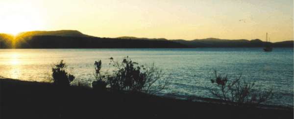
How long does it take to get from glitzy resort to pristine isolation? Depends on the direction and speed, but if you start from Airlie Beach, less than half hour in a motor boat or an hour and a half under sail gets you there. Because of charter boat rules and inertia, the Airlie and Shute Harbour traffic rarely deviates from the well trodden path to the Hook and Whitsunday Island areas.
The ragged coastline between Pioneer Bay, a.k.a. “the freeway” and Gloucester Passage, has a number of brilliant anchoring opportunities, especially in the prevailing winds (SE). Woodwark Bay is actually the closest isolated spot north of Airlie. It's a good spot, and one we will cover in a future feature, but East Double Bay has a unique attraction.
In years passed, a lot of weekend fishing shacks were built on crown land when no one cared. Then the bulldozers moved on them. But, some spots are so isolated it would take a bulldozer a week just to get to them. Maybe that's why one still stands in East Double Bay.
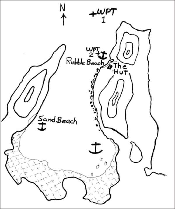
Sheltered behind the hills of the headland, and just back from the anchorage at Rubble Beach is “The Hut”. No one would call it flash, but it's all there and because of the efforts of a few regular users, it's tidy and even semi-provisioned.
There is a kitchen with wood fired stove, sink with running water, and a few bits of cookware. The bedroom has a double bed, and set up with spare mattresses and frames folded in a corner next to the old fridge. The living room has a sturdy wood table and benches…or is that the dining room? In the adjoining veranda, a few chairs are scattered about. The cupboard by the back door is stocked with coffee, tea and the lot. Often you may find things like onions or potatoes included. You are invited to use what you will, and encouraged to leave what you can.
On shelving around the place lie the trophies of years of beach combing, and memorabilia left by passers by. When we were last there, there was even most of a bottle of home brew rum left by some very charitable boatie. My mate Tyrone, who is expert in such matters, had a taste and pronounced it worthy.
Out back is a well cared for water tank connected to a surprisingly good gutter system. In spite of little rain lately, I found the tank about 2/3 full. Around the corner is the shower equipped with a plastic solar heat bag you can fill in the kitchen. Further afield is the dunny that is reasonable enough.
In between the hut and the dunny lies the problem. There are some things that years ago you could get away with that just aren't “on” anymore. For example, back when Nara Inlet on Hook Island might see a boat a week, people would paint their boat's name on the rocks. At the time, relatively harmless, but it's a different world now. Back in the old days at the hut, many people tossed their beer cans and such in a heap out back. Some haven't
Figured out that you shouldn't do that anymore. While we were there, we filled 2 large garbage bags from the “tip” to take with us, and we encourage others to do the same, or at least what you can.“The Hut” is a perfect gathering place for the special groups of social boaties. Only a few miles from “Gomorrah”.
GETTING THERE
*From Pioneer Bay, aim for Grimston Pt., then about 275°M to round the next headland, and in. Neither headland has any special obstruction. Reasonable prudence gets you by. Especially if you are sailing, it's wise to work the current. A run out takes you there, a flood makes slow work of it, especially off Grimston Pt. It's about 8 ¾ miles to Waypoint #1 from Shingley Beach.
*From Gloucester Passage, round either side of Saddleback Island (watch the sandbar on the west side), and then around Georges Point. Making south between Olden and Grassy Islands and the mainland gets you out of some of the tide. If you are working it, stay outside in the deeper, faster water. It's about 14 miles from Montes Resort all up.
Watch out for Edwin Rock, about .8 mile north of Grassy…it can sneak up on you.
*As anywhere around the Whitsunday's, wind against tide makes bumpy seas.
*With “Rubble Beach” and the large and slightly better anchorage further in, you've
got coverage for strong southerlies to moderate north-east winds. If it is south-west to north-west, Sandy Beach on the other side is the go. There used to be a hut there, but it's apparently been burned down.*If it comes a strong northerly, you don't want to be there. Flee for the south side of Grassy Island, only 2 miles off at about 310°M from Rubble Beach.
*Watch for “Datum Rock”, on the south end of Rubble Beach. Though it's on all the charts, I've never had low enough water to see it. It must be there somewhere…
SEE YOU AT “CLUB DOUBLE”!
P.S. Last time we were there, we left a stack of garbage bags. Please use!